 BRFM
BRFM Cold snap on it’s way? – Wrap up your pipes
Written by karen on 26 October 2018
Southern Water encourages customers to prepare for the predicted cold weather.
![]()
A cold snap is on the way and Southern Water are encouraging customers to start preparing now to help prevent pipes from freezing and bursting.
“Although it’s still autumn, it’s never too early to prepare your pipes for the cold snap that’s been predicted into next week,” said Helen Simonian, Director of Water Services at Southern Water.
“Lagging exposed pipes in your loft, as well as your external pipes, can help prevent bursts and flooding in your home but – should the worst happen – make sure you know where your internal stop tap is, so you can turn the water off as soon as possible.
“You should also try and fix any dripping taps, as even a small trickle could result in a frozen pipe.
“Finally, we’re asking our customers to help us be our eyes and ears out and about, and to report any leaks they spot on our 24-hour leak line:
0800 820 999”
Burst pipes can happen at any time of the year we are also reminding customers that during 2018, we are offering one free fix on external
pipes between your property and our water main, so any pipe that bursts during the cold snap might qualify.
This Weekend
Temperatures are predicted to plummet as early as this evening to just 1C in some areas across Kent, as a plume of arctic air sweeps the UK today (Friday) pushing temperatures below freezing at times bringing harsh widespread frosts. 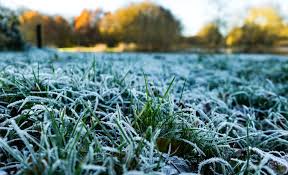
This weekend is set to be the coldest of the Autumn so far.
Met Office meteorologist Greg Dewhurst said: “People are going to notice a huge change from the start of the week when it was relatively mild.
“Cold Arctic air will start to move in on Thursday night and will be across the whole country by the end of Friday.
“Snow is likely to accumulate across high ground of Scotland and the north and we will see showers turn wintry further south, across northern and parts of central Britain.
“Saturday is likely to be the coldest day of this cold snap and even during the day most places will struggle to get close to double figures.”
“There will be a risk of sharp overnight frosts as we go into the weekend and into next week when it should turn slightly milder.”
Regional Forecast (Friday, Saturday & Sunday)
This Evening & Tonight: Evening showers will fade, with clear skies developing. However staying a little cloudier across east Kent, with the odd shower possible. Feeling cold, with a brisk northerly breeze. A widespread frost is likely by dawn, especially across rural western parts. Minimum temperature 0 °C
Saturday: Cold start, with some sunny spells and brisk northerly winds. Cloud then thickens through the morning, bringing a risk of showers. These heavy at times with a risk of hail. Maximum temperature 8 °C
Sunday: Cold, with brisk northeasterly winds Sunday and Monday. Often cloudy, with showers, occasionally heavy. Some sunny spells, these most prolonged in the west.

Continue reading